
伊斯利普镇的改建规划The maps of a small town called Islip and plans for its development
AI 估评 7.5 分查看四维评分详情
四个维度等权计分,均值 7.5,按半分档展示。AI 估评供学习参考。
任务完成度 TA7 / 9
主要交通和设施变化覆盖清楚,方位基本准确;但称学校将略扩建无图示支持,公园缩小也弱化为slightly,且停车场位置重复交代。
档位依据:清晰概述与主要变化支持7档;局部新增和程度不准确限制8档。
查看评分证据
a dual carriageway ring road will be built to encircle the town centre
准确识别最主要交通变化。
the school in the southwest will be expanded slightly
学校位置保留可见,扩建判断无图示支持。
- 题图证据
已看两幅地图:现状南部学校、公园和住宅,北部乡村;规划环形双向车道包围中心,内为步行街和商店,北边依次车站、购物中心、停车场及新住宅,东南公园明显缩小、旁有新住宅。学校仍在西南,图中没有扩建标记且轮廓不更大。
改进建议
- 删除学校扩建,保留位置未变;把公园描述为变小而不妄加slightly。
连贯与衔接 CC7 / 9
现状与规划分段明确,空间描述有序;规划段把多个变化压进长句,停车场介绍两次,衔接Besides稍生硬。
档位依据:清楚推进达到7档;冗余与段内拥挤限制8档。
查看评分证据
The northern area, by contrast, is largely countryside at the moment.
对照南北现状自然。
To the east, car parking will be provided
前句已列car park,这里重复而位置更泛。
改进建议
- 把交通改造与建筑变化各成一段,合并停车场信息。
词汇资源 LR8 / 9
flanked、pedestrianised、dual carriageway、encircle、make way for等地图词准确且灵活;modernise偏概括但可理解。
档位依据:词汇范围充分且搭配成熟达到8档;少量程度词不精确,未充分到9档。
查看评分证据
flanked by shops on both its north and south sides
位置关系搭配自然。
removed to make way for a new shopping centre
拆除替换的表达准确。
改进建议
- 对没有精确尺度的变化避免slightly等强行定程度词。
语法范围与准确性 GRA8 / 9
被动未来时、分词、while/but对照及关系从句较准确,长句仍能理解;several与housing并列处有小错误。
档位依据:多样结构且多数句无误达到8档;孤立名词数量搭配错误及过长句限制9档。
查看评分证据
adding several housing and public amenities
housing不可直接受several修饰,可写housing units。
allowing the main east-west road to be transformed into a pedestrian-only street
分词与不定式被动准确。
改进建议
- 改为adding new housing and several public amenities,并拆分过长的南侧变化句。
评分日期:2026-10-23 · 评分规则:IELTS 写作公开评分标准(2023 年 5 月版)
作文题目
来源页题目,与同页选定答案配套;未核为实际考试真题
The maps below show the centre of a small town called Islip as it is now, and plans for its development.
Summarise the information by selecting and reporting the main features, and make comparisons where relevant.
Write at least 150 words.
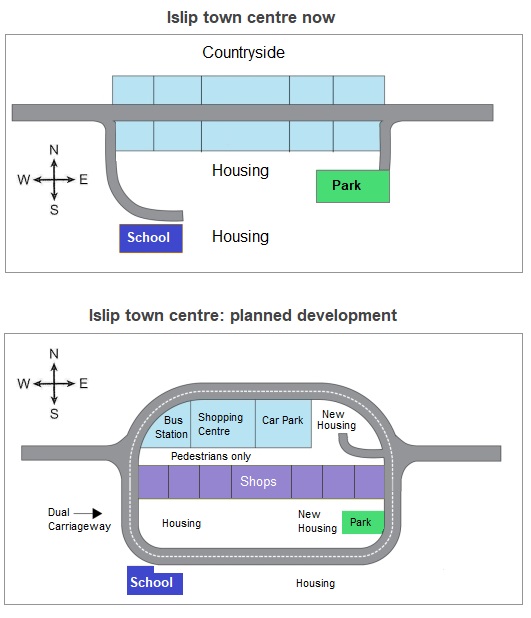
The first map illustrates the current layout of the centre of a small town called Islip, and the second map depicts a proposed plan for this town’s future development.
Generally speaking, the development plan aims to modernise the town centre by improving transport infrastructure, creating a pedestrianised main street, and adding several housing and public amenities.
In the present-day map, a single main road runs east-west across the town centre, flanked by shops on both its north and south sides. To the south, there is a residential area, a school in the southwest, and a park to the southeast. The northern area, by contrast, is largely countryside at the moment.
Under the proposed plan, a dual carriageway ring road will be built to encircle the town centre, allowing the main east-west road to be transformed into a pedestrian-only street. Besides, the town’s northern shops are to be removed to make way for a new shopping centre, bus station, car park, and new housing units. To the east, car parking will be provided, while on the southern side of the main road, many of the existing shops will remain, but the development plan also includes more houses, which will slightly reduce the size of the current park. Meanwhile, the school in the southwest will be expanded slightly, but it will retain its existing location.
- 文章身份
- 机构教研范文
- 题目来源
- 教学题目