
诺比顿工业区改造规划Maps of an industrial area in the town of Norbiton
AI 估评 8 分查看四维评分详情
四个维度等权计分,均值 7.75,按半分档展示。AI 估评供学习参考。
任务完成度 TA7 / 9
工厂改住房和主要道路、设施均准确覆盖,概述明确;北岸农田保留未说明,游乐场与学校都笼统放在道路尽头,空间细节略粗。
档位依据:关键变化和清楚概述支持7档;细节位置与保留项不足限制8档。
查看评分证据
Farmland on the northern bank of the river is also slated for residential development
仅部分土地改建,东侧仍标农田。
a playground and a school are added at the end of that road
学校在端点,游乐场在道路北侧支路上。
- 题图证据
已看上下地图:现八厂集中在大环岛和东路两侧,北为河与农田;规划住房替厂,北路过河至一排住房和横向尽端路,农田保留在其东,西北新增支路;学校在东端,游乐场在东路北侧;南增小环岛,商店西、医疗东。
改进建议
- 注明部分农田保留,并分别定位学校东端和游乐场北侧。
连贯与衔接 CC8 / 9
现状与规划分段清楚,未来以中心环岛辐射到北、东、西北、南,空间参照稳定。
档位依据:组织及衔接达到8档;来回转换方向可更系统以接近9档。
查看评分证据
From the central roundabout, a new northbound road will be constructed
确定共同空间起点。
In addition, a second roundabout is planned along the southern road
收束南侧变化清楚。
改进建议
- 按顺时针方向连续介绍新设施,减少方位跳转。
词汇资源 LR8 / 9
residential neighbourhood、complemented、flanked、slated等自然丰富;enhanced等评价词较泛。
档位依据:范围和流畅度支持8档;抽象评价与个别位置精度限制9档。
查看评分证据
a residential neighbourhood, complemented by essential public amenities
用途转变词汇自然。
also flanked by new houses
自然说明道路两侧住房。
改进建议
- 用具体新增道路和设施替代enhanced的笼统评价。
语法范围与准确性 GRA8 / 9
被动将来、分词修饰、倒装和并列结构准确,多数句无误。
档位依据:句式广泛且控制稳定达到8档;规划长句可更精炼以接近9档。
查看评分证据
To the north lies a river, and beyond the river, farmland.
方位倒装和省略正确。
crossing the river via a bridge and running alongside new homes
并列分词关系准确。
改进建议
- 拆开北岸道路与住宅的长句,以明确土地保留范围。
评分日期:2026-10-23 · 评分规则:IELTS 写作公开评分标准(2023 年 5 月版)
作文题目
来源页题目,与同页选定答案配套;未核为实际考试真题
The maps below show an industrial area in the town of Norbiton, and planned future development of the site.
Summarise the information by selecting and reporting the main features, and make comparisons where relevant.
Write at least 150 words.
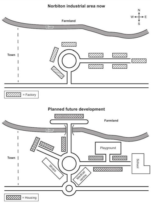
The two maps depict the present-day layout of an industrial zone in Norbiton and the proposed redevelopment plan for the same area.
As the maps depict, the redevelopment aims to replace the industrial factories with a residential neighbourhood, complemented by essential public amenities and enhanced road infrastructure.
In the current map, the area is dominated by eight factories arranged around a central roundabout, which links a southern road and an eastern road. To the north lies a river, and beyond the river, farmland. The town is located to the west of the industrial site. The area has no school, medical facility, or residential buildings, but only industrial infrastructure.
In the future plan of this area, all the factories are removed and replaced with housing. From the central roundabout, a new northbound road will be constructed, crossing the river via a bridge and running alongside new homes. Farmland on the northern bank of the river is also slated for residential development, with a parallel road linking to the northbound road. On the eastern side of the roundabout, housing continues, and a playground and a school are added at the end of that road. To the northwest, another new road will branch off, also flanked by new houses. In addition, a second roundabout is planned along the southern road, with shops to the west and a medical centre to the east.
- 文章身份
- 机构教研范文
- 题目来源
- 教学题目